'This dataset provides a Climate Data Record of Sea Ice Thickness for the southern hemisphere polar region, derived from the RA-2 (Radar Altimeter -2) instrument on the Envisat satellite at Level 3C (L3C). This product was generated in the context of the ESA Climate Change Initiative Programme (ESA CCI) by the Sea Ice CCI (Sea_Ice_cci) project.It provides monthly gridded sea ice thickness data on a Lambeth Azimuthal Equal Area Projection for the period October 2002 to March 2012. Note, the southern hemisphere sea ice thickness dataset is an experimental climate data record, as the algorithm does not properly consider the impact of the complex snow morphology in the freeboard retrieval. Sea ice thickness is provided for all months but needs to be considered biased high in areas with high snow depth and during the southern summer months. Please consult the Product User Guide (PUG) for more information.',
'This dataset provides a Climate Data Record of Sea Ice Thickness for the southern hemisphere polar region, derived from the RA-2 (Radar Altimeter -2) instrument on the Envisat satellite at Level 3C (L3C). This product was generated in the context of the ESA Climate Change Initiative Programme (ESA CCI) by the Sea Ice CCI (Sea_Ice_cci) project.It provides monthly gridded sea ice thickness data on a Lambeth Azimuthal Equal Area Projection for the period October 2002 to March 2012. Note, the southern hemisphere sea ice thickness dataset is an experimental climate data record, as the algorithm does not properly consider the impact of the complex snow morphology in the freeboard retrieval. Sea ice thickness is provided for all months but needs to be considered biased high in areas with high snow depth and during the southern summer months. Please consult the Product User Guide (PUG) for more information.',
'This dataset provides a Climate Data Record of Sea Ice Thickness for the southern hemisphere polar region, derived from the RA-2 (Radar Altimeter -2) instrument on the Envisat satellite at Level 3C (L3C). This product was generated in the context of the ESA Climate Change Initiative Programme (ESA CCI) by the Sea Ice CCI (Sea_Ice_cci) project.It provides monthly gridded sea ice thickness data on a Lambeth Azimuthal Equal Area Projection for the period October 2002 to March 2012. Note, the southern hemisphere sea ice thickness dataset is an experimental climate data record, as the algorithm does not properly consider the impact of the complex snow morphology in the freeboard retrieval. Sea ice thickness is provided for all months but needs to be considered biased high in areas with high snow depth and during the southern summer months. Please consult the Product User Guide (PUG) for more information.',
'This dataset provides a Climate Data Record of Sea Ice Thickness for the southern hemisphere polar region, derived from the RA-2 (Radar Altimeter -2) instrument on the Envisat satellite at Level 3C (L3C). This product was generated in the context of the ESA Climate Change Initiative Programme (ESA CCI) by the Sea Ice CCI (Sea_Ice_cci) project.It provides monthly gridded sea ice thickness data on a Lambeth Azimuthal Equal Area Projection for the period October 2002 to March 2012. Note, the southern hemisphere sea ice thickness dataset is an experimental climate data record, as the algorithm does not properly consider the impact of the complex snow morphology in the freeboard retrieval. Sea ice thickness is provided for all months but needs to be considered biased high in areas with high snow depth and during the southern summer months. Please consult the Product User Guide (PUG) for more information.',
'This dataset provides a Climate Data Record of Sea Ice Thickness for the southern hemisphere polar region, derived from the RA-2 (Radar Altimeter -2) instrument on the Envisat satellite at Level 3C (L3C). This product was generated in the context of the ESA Climate Change Initiative Programme (ESA CCI) by the Sea Ice CCI (Sea_Ice_cci) project.It provides monthly gridded sea ice thickness data on a Lambeth Azimuthal Equal Area Projection for the period October 2002 to March 2012. Note, the southern hemisphere sea ice thickness dataset is an experimental climate data record, as the algorithm does not properly consider the impact of the complex snow morphology in the freeboard retrieval. Sea ice thickness is provided for all months but needs to be considered biased high in areas with high snow depth and during the southern summer months. Please consult the Product User Guide (PUG) for more information.',
'This dataset provides a Climate Data Record of Sea Ice Thickness for the southern hemisphere polar region, derived from the RA-2 (Radar Altimeter -2) instrument on the Envisat satellite at Level 3C (L3C). This product was generated in the context of the ESA Climate Change Initiative Programme (ESA CCI) by the Sea Ice CCI (Sea_Ice_cci) project.It provides monthly gridded sea ice thickness data on a Lambeth Azimuthal Equal Area Projection for the period October 2002 to March 2012. Note, the southern hemisphere sea ice thickness dataset is an experimental climate data record, as the algorithm does not properly consider the impact of the complex snow morphology in the freeboard retrieval. Sea ice thickness is provided for all months but needs to be considered biased high in areas with high snow depth and during the southern summer months. Please consult the Product User Guide (PUG) for more information.',
'This dataset provides a Climate Data Record of Sea Ice Thickness for the southern hemisphere polar region, derived from the RA-2 (Radar Altimeter -2) instrument on the Envisat satellite at Level 3C (L3C). This product was generated in the context of the ESA Climate Change Initiative Programme (ESA CCI) by the Sea Ice CCI (Sea_Ice_cci) project.It provides monthly gridded sea ice thickness data on a Lambeth Azimuthal Equal Area Projection for the period October 2002 to March 2012. Note, the southern hemisphere sea ice thickness dataset is an experimental climate data record, as the algorithm does not properly consider the impact of the complex snow morphology in the freeboard retrieval. Sea ice thickness is provided for all months but needs to be considered biased high in areas with high snow depth and during the southern summer months. Please consult the Product User Guide (PUG) for more information.',
'This dataset provides a Climate Data Record of Sea Ice Thickness for the southern hemisphere polar region, derived from the RA-2 (Radar Altimeter -2) instrument on the Envisat satellite at Level 3C (L3C). This product was generated in the context of the ESA Climate Change Initiative Programme (ESA CCI) by the Sea Ice CCI (Sea_Ice_cci) project.It provides monthly gridded sea ice thickness data on a Lambeth Azimuthal Equal Area Projection for the period October 2002 to March 2012. Note, the southern hemisphere sea ice thickness dataset is an experimental climate data record, as the algorithm does not properly consider the impact of the complex snow morphology in the freeboard retrieval. Sea ice thickness is provided for all months but needs to be considered biased high in areas with high snow depth and during the southern summer months. Please consult the Product User Guide (PUG) for more information.',
'This dataset provides a Climate Data Record of Sea Ice Thickness for the southern hemisphere polar region, derived from the RA-2 (Radar Altimeter -2) instrument on the Envisat satellite at Level 3C (L3C). This product was generated in the context of the ESA Climate Change Initiative Programme (ESA CCI) by the Sea Ice CCI (Sea_Ice_cci) project.It provides monthly gridded sea ice thickness data on a Lambeth Azimuthal Equal Area Projection for the period October 2002 to March 2012. Note, the southern hemisphere sea ice thickness dataset is an experimental climate data record, as the algorithm does not properly consider the impact of the complex snow morphology in the freeboard retrieval. Sea ice thickness is provided for all months but needs to be considered biased high in areas with high snow depth and during the southern summer months. Please consult the Product User Guide (PUG) for more information.',
'This dataset provides a Climate Data Record of Sea Ice Thickness for the southern hemisphere polar region, derived from the RA-2 (Radar Altimeter -2) instrument on the Envisat satellite at Level 3C (L3C). This product was generated in the context of the ESA Climate Change Initiative Programme (ESA CCI) by the Sea Ice CCI (Sea_Ice_cci) project.It provides monthly gridded sea ice thickness data on a Lambeth Azimuthal Equal Area Projection for the period October 2002 to March 2012. Note, the southern hemisphere sea ice thickness dataset is an experimental climate data record, as the algorithm does not properly consider the impact of the complex snow morphology in the freeboard retrieval. Sea ice thickness is provided for all months but needs to be considered biased high in areas with high snow depth and during the southern summer months. Please consult the Product User Guide (PUG) for more information.',
'This dataset provides a Climate Data Record of Sea Ice Thickness for the southern hemisphere polar region, derived from the RA-2 (Radar Altimeter -2) instrument on the Envisat satellite at Level 3C (L3C). This product was generated in the context of the ESA Climate Change Initiative Programme (ESA CCI) by the Sea Ice CCI (Sea_Ice_cci) project.It provides monthly gridded sea ice thickness data on a Lambeth Azimuthal Equal Area Projection for the period October 2002 to March 2012. Note, the southern hemisphere sea ice thickness dataset is an experimental climate data record, as the algorithm does not properly consider the impact of the complex snow morphology in the freeboard retrieval. Sea ice thickness is provided for all months but needs to be considered biased high in areas with high snow depth and during the southern summer months. Please consult the Product User Guide (PUG) for more information.',
'This dataset provides a Climate Data Record of Sea Ice Thickness for the southern hemisphere polar region, derived from the RA-2 (Radar Altimeter -2) instrument on the Envisat satellite at Level 3C (L3C). This product was generated in the context of the ESA Climate Change Initiative Programme (ESA CCI) by the Sea Ice CCI (Sea_Ice_cci) project.It provides monthly gridded sea ice thickness data on a Lambeth Azimuthal Equal Area Projection for the period October 2002 to March 2012. Note, the southern hemisphere sea ice thickness dataset is an experimental climate data record, as the algorithm does not properly consider the impact of the complex snow morphology in the freeboard retrieval. Sea ice thickness is provided for all months but needs to be considered biased high in areas with high snow depth and during the southern summer months. Please consult the Product User Guide (PUG) for more information.',
'This dataset provides a Climate Data Record of Sea Ice Thickness for the southern hemisphere polar region, derived from the RA-2 (Radar Altimeter -2) instrument on the Envisat satellite at Level 3C (L3C). This product was generated in the context of the ESA Climate Change Initiative Programme (ESA CCI) by the Sea Ice CCI (Sea_Ice_cci) project.It provides monthly gridded sea ice thickness data on a Lambeth Azimuthal Equal Area Projection for the period October 2002 to March 2012. Note, the southern hemisphere sea ice thickness dataset is an experimental climate data record, as the algorithm does not properly consider the impact of the complex snow morphology in the freeboard retrieval. Sea ice thickness is provided for all months but needs to be considered biased high in areas with high snow depth and during the southern summer months. Please consult the Product User Guide (PUG) for more information.',
'This dataset provides a Climate Data Record of Sea Ice Thickness for the southern hemisphere polar region, derived from the RA-2 (Radar Altimeter -2) instrument on the Envisat satellite at Level 3C (L3C). This product was generated in the context of the ESA Climate Change Initiative Programme (ESA CCI) by the Sea Ice CCI (Sea_Ice_cci) project.It provides monthly gridded sea ice thickness data on a Lambeth Azimuthal Equal Area Projection for the period October 2002 to March 2012. Note, the southern hemisphere sea ice thickness dataset is an experimental climate data record, as the algorithm does not properly consider the impact of the complex snow morphology in the freeboard retrieval. Sea ice thickness is provided for all months but needs to be considered biased high in areas with high snow depth and during the southern summer months. Please consult the Product User Guide (PUG) for more information.',
'This dataset provides a Climate Data Record of Sea Ice Thickness for the southern hemisphere polar region, derived from the RA-2 (Radar Altimeter -2) instrument on the Envisat satellite at Level 3C (L3C). This product was generated in the context of the ESA Climate Change Initiative Programme (ESA CCI) by the Sea Ice CCI (Sea_Ice_cci) project.It provides monthly gridded sea ice thickness data on a Lambeth Azimuthal Equal Area Projection for the period October 2002 to March 2012. Note, the southern hemisphere sea ice thickness dataset is an experimental climate data record, as the algorithm does not properly consider the impact of the complex snow morphology in the freeboard retrieval. Sea ice thickness is provided for all months but needs to be considered biased high in areas with high snow depth and during the southern summer months. Please consult the Product User Guide (PUG) for more information.',
'This dataset provides a Climate Data Record of Sea Ice Thickness for the southern hemisphere polar region, derived from the RA-2 (Radar Altimeter -2) instrument on the Envisat satellite at Level 3C (L3C). This product was generated in the context of the ESA Climate Change Initiative Programme (ESA CCI) by the Sea Ice CCI (Sea_Ice_cci) project.It provides monthly gridded sea ice thickness data on a Lambeth Azimuthal Equal Area Projection for the period October 2002 to March 2012. Note, the southern hemisphere sea ice thickness dataset is an experimental climate data record, as the algorithm does not properly consider the impact of the complex snow morphology in the freeboard retrieval. Sea ice thickness is provided for all months but needs to be considered biased high in areas with high snow depth and during the southern summer months. Please consult the Product User Guide (PUG) for more information.',
'This dataset provides a Climate Data Record of Sea Ice Thickness for the southern hemisphere polar region, derived from the RA-2 (Radar Altimeter -2) instrument on the Envisat satellite at Level 3C (L3C). This product was generated in the context of the ESA Climate Change Initiative Programme (ESA CCI) by the Sea Ice CCI (Sea_Ice_cci) project.It provides monthly gridded sea ice thickness data on a Lambeth Azimuthal Equal Area Projection for the period October 2002 to March 2012. Note, the southern hemisphere sea ice thickness dataset is an experimental climate data record, as the algorithm does not properly consider the impact of the complex snow morphology in the freeboard retrieval. Sea ice thickness is provided for all months but needs to be considered biased high in areas with high snow depth and during the southern summer months. Please consult the Product User Guide (PUG) for more information.',
'This dataset provides a Climate Data Record of Sea Ice Thickness for the southern hemisphere polar region, derived from the RA-2 (Radar Altimeter -2) instrument on the Envisat satellite at Level 3C (L3C). This product was generated in the context of the ESA Climate Change Initiative Programme (ESA CCI) by the Sea Ice CCI (Sea_Ice_cci) project.It provides monthly gridded sea ice thickness data on a Lambeth Azimuthal Equal Area Projection for the period October 2002 to March 2012. Note, the southern hemisphere sea ice thickness dataset is an experimental climate data record, as the algorithm does not properly consider the impact of the complex snow morphology in the freeboard retrieval. Sea ice thickness is provided for all months but needs to be considered biased high in areas with high snow depth and during the southern summer months. Please consult the Product User Guide (PUG) for more information.',
'This dataset provides a Climate Data Record of Sea Ice Thickness for the southern hemisphere polar region, derived from the RA-2 (Radar Altimeter -2) instrument on the Envisat satellite at Level 3C (L3C). This product was generated in the context of the ESA Climate Change Initiative Programme (ESA CCI) by the Sea Ice CCI (Sea_Ice_cci) project.It provides monthly gridded sea ice thickness data on a Lambeth Azimuthal Equal Area Projection for the period October 2002 to March 2012. Note, the southern hemisphere sea ice thickness dataset is an experimental climate data record, as the algorithm does not properly consider the impact of the complex snow morphology in the freeboard retrieval. Sea ice thickness is provided for all months but needs to be considered biased high in areas with high snow depth and during the southern summer months. Please consult the Product User Guide (PUG) for more information.',
'This dataset provides a Climate Data Record of Sea Ice Thickness for the southern hemisphere polar region, derived from the RA-2 (Radar Altimeter -2) instrument on the Envisat satellite at Level 3C (L3C). This product was generated in the context of the ESA Climate Change Initiative Programme (ESA CCI) by the Sea Ice CCI (Sea_Ice_cci) project.It provides monthly gridded sea ice thickness data on a Lambeth Azimuthal Equal Area Projection for the period October 2002 to March 2012. Note, the southern hemisphere sea ice thickness dataset is an experimental climate data record, as the algorithm does not properly consider the impact of the complex snow morphology in the freeboard retrieval. Sea ice thickness is provided for all months but needs to be considered biased high in areas with high snow depth and during the southern summer months. Please consult the Product User Guide (PUG) for more information.',
radar freeboard is defined as the elevation based on the assumption of vacuum light speed without a snow propagation or range penetration correction
coverage_content_type :
physicalMeasurement
grid_mapping :
Lambert_Azimuthal_Grid
long_name :
radar freeboard
units :
m
[46656 values with dtype=float32]
radar_freeboard_uncertainty
(time, yc, xc)
float32
...
comment :
algorithm uncertainty (error propagation) of sea ice thickness including uncertainty reduction of random components by gridding
coverage_content_type :
qualityInformation
grid_mapping :
Lambert_Azimuthal_Grid
long_name :
uncertainty associated with radar freeboard
units :
m
[46656 values with dtype=float32]
region_code
(time, yc, xc)
int8
...
comment :
Region code from Antarctic seas based on their longitude range with additional latitude cut-off at 40S (see Parkinson, C. L. and Cavalieri, D. J. (2012), Antarctic sea ice variability and trends, 1979 - 2010, The Cryosphere)
coverage_content_type :
referenceInformation
flag_meanings :
land_ice ice_free_ocean indian_ocean western_pacific_ocean ross_sea bellingshausen_and_amundsen_seas weddell_sea land
flag_values :
[ 0 1 2 3 4 5 6 20]
grid_mapping :
Lambert_Azimuthal_Grid
long_name :
region code
units :
1
valid_max :
20
valid_min :
0
[46656 values with dtype=int8]
sea_ice_concentration
(time, yc, xc)
float32
...
coverage_content_type :
auxiliaryInformation
grid_mapping :
Lambert_Azimuthal_Grid
long_name :
sea ice concentration
standard_name :
sea_ice_area_fraction
units :
percent
valid_max :
100.0
valid_min :
0.0
[46656 values with dtype=float32]
sea_ice_freeboard
(time, yc, xc)
float32
...
ancillary_variables :
sea_ice_freeboard_uncertainty, region_code
coverage_content_type :
physicalMeasurement
grid_mapping :
Lambert_Azimuthal_Grid
long_name :
sea ice freeboard
standard_name :
sea_ice_freeboard
units :
m
[46656 values with dtype=float32]
sea_ice_freeboard_uncertainty
(time, yc, xc)
float32
...
comment :
algorithm uncertainty (error propagation) of sea ice thickness including uncertainty reduction of random components by gridding
Alfred-Wegener-Institut Helmholtz Zentrum für Polar und Meeresforschung
source :
Altimetry: envisat, Snow depth: ESA-SICCI AMSR-E/AMSR2 snow depth on sea ice climatology, Mean Sea Surface: DTU21 global mean sea surface, Sea ice Concentration: C3S Sea Ice Concentration CDR/ICDR v3.0, Sea ice type: First-year sea ice only, Region code: Longitude-based sectors from Parkinson, C. L. and Cavalieri, D. J. (2012)
platform :
None
sensor :
RA-2
history :
20240220T162330Z - Product generated with pysiral version 0.9.6
Gridded Southern Hemisphere Sea Ice Thickness Climate Data Record from Envisat and CryoSat-2 satellite radar altimetry for the period June 2002 - April 2020.
Southern hemisphere sea ice thickness is an experimental climate data record, as the algorithm does not properly considers the impact of the complex snow morphology in the freeboard retrieval. Sea ice thickness is provided for all month but needs to be considered biased high in areas with high snow depth and during the southern summer month. Please consult the Product User Guide (PUG) for more information.
date_created :
20240220T162330Z
creator_name :
Alfred-Wegener-Institut Helmholtz Zentrum für Polar und Meeresforschung
creator_type :
institution
creator_url :
http://www.awi.de
contributor_name :
Stefan Hendricks, Stephan Paul, Eero Rinne, heidi.sallila@fmi.fi
contributor_role :
PrincipalInvestigator, Author, Author, Author
project :
Climate Change Initiative - European Space Agency
geospatial_lat_min :
-89.6835
geospatial_lat_max :
-16.8229
geospatial_lon_min :
-179.7335
geospatial_lon_max :
179.7335
geospatial_vertical_min :
0.0
geospatial_vertical_max :
0.0
spatial_resolution :
50km grid spacing
geospatial_bounds_crs :
EPSG:6932
time_coverage_start :
2008-01-01T00:00:00
time_coverage_end :
2008-01-31T23:59:59.999999
time_coverage_duration :
P1M
time_coverage_resolution :
P1M
standard_name_vocabulary :
CF Standard Name Table v77
license :
other
_id :
SEA_ICE_THICKNESS_L3C_ENVISAT_V3.0_SH
abstract :
This dataset provides a Climate Data Record of Sea Ice Thickness for the southern hemisphere polar region, derived from the RA-2 (Radar Altimeter -2) instrument on the Envisat satellite at Level 3C (L3C). This product was generated in the context of the ESA Climate Change Initiative Programme (ESA CCI) by the Sea Ice CCI (Sea_Ice_cci) project.It provides monthly gridded sea ice thickness data on a Lambeth Azimuthal Equal Area Projection for the period October 2002 to March 2012. Note, the southern hemisphere sea ice thickness dataset is an experimental climate data record, as the algorithm does not properly consider the impact of the complex snow morphology in the freeboard retrieval. Sea ice thickness is provided for all months but needs to be considered biased high in areas with high snow depth and during the southern summer months. Please consult the Product User Guide (PUG) for more information.
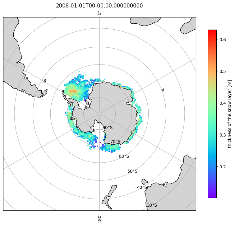
importmatplotlib.pyplotaspltimportcartopy.crsasccrsimportcartopy.featureascfeature# Take the first time DataArray for snow_depthda=ds.snow_depth.isel(time=0)# Use a South Polar Stereographic projectionproj=ccrs.SouthPolarStereo()fig=plt.figure(figsize=(10,10))ax=plt.axes(projection=proj)# Add coastlines, land and gridlines\n",ax.coastlines()ax.add_feature(cfeature.LAND,facecolor="lightgray")ax.gridlines(draw_labels=True)# Plot the datapcm=ax.pcolormesh(da["lon"],da["lat"],da,transform=ccrs.PlateCarree(),cmap="rainbow")# Colorbarcb=plt.colorbar(pcm,ax=ax,orientation="vertical",shrink=0.7,pad=0.05)cb.set_label(f"{da.attrs.get('long_name','value')} [{da.attrs.get('units','')}]")plt.title(da['time'].values)plt.show()